Forest balance
& canopy change.
A forest can keep its land-use label while losing its canopy. These maps measure different parts of the story.
ForTy maps less forest in both massifs. Copernicus shows a small crown-area decrease in Făgăraș and an increase in Retezat. The periods and measurements differ.
| Measurement & period | Făgăraș | Retezat |
|---|---|---|
| Forest area · net changeForTy v2 beta · 2017–2025 | −1,018.44 ha | −97.62 ha |
| Canopy disturbance · lossHansen GFC · 2018–2025 | 2,545.69 ha | 180.12 ha |
| Crown-covered area · net changeCopernicus density · 2018–2024 | −75.10 ha | +294.97 ha |
These totals follow published massif polygons, unlike the landscape explorer’s rectangular study areas. Different products’ losses and gains cannot be combined into a net figure.
What happened
to the canopy?
Canopy disturbance and forest land use answer different questions. Hansen detects loss events; Copernicus measures changes in tree-covered extent and crown density.
Hansen · disturbance on a 30 m grid
2018–2025| Massif | Hansen loss | Both products | ForTy loss only | Hansen loss only |
|---|---|---|---|---|
| Făgăraș | 2,545.69 | 1,102.83 | 207.79 | 1,442.86 |
| Retezat | 180.12 | 85.34 | 46.24 | 94.78 |
Hansen loss may reflect harvest, mortality, fire, or other disturbance. The comparison uses ForTy forest in 2017 as its baseline, with fractional 10 m support on an aligned 30 m equal-area grid. No year-2000 canopy-density threshold was applied, so these totals differ from default Global Forest Watch statistics. Repeated losses at one pixel are not fully represented.
Overlap shows cross-product agreement; it does not independently validate either product, the cause of loss, or permanent deforestation.
Copernicus · the area covered by tree crowns
2018–2024| Massif | 2018 crowns | 2024 crowns | Decrease | Increase | Net change |
|---|---|---|---|---|---|
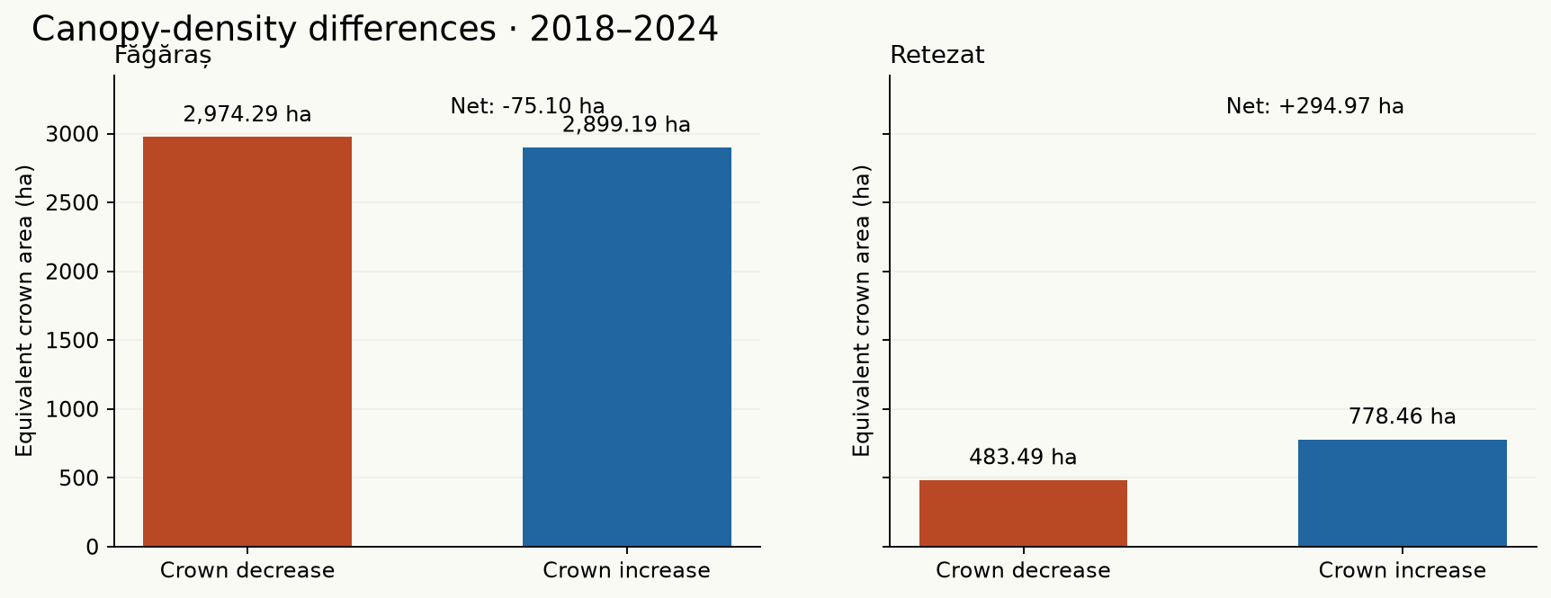
| Făgăraș | 92,121.63 | 92,046.53 | 2,974.29 | 2,899.19 | −75.10 |
| Retezat | 23,984.78 | 24,279.76 | 483.49 | 778.46 | +294.97 |
Tree Cover Density measures vertical crown projection: density / 100 × 0.01 ha per 10 m cell. Positive and negative differences describe spatial change between 2018 and 2024, rather than cumulative annual events.
Where tree-covered extent changed
20 m support| Massif | Period | Canopy lost | Canopy gained | Canopy net | ForTy forest net |
|---|---|---|---|---|---|
| Făgăraș | 2018–2021 | 501.60 | 39.88 | −461.72 | −452.45 |
| Făgăraș | 2021–2024 | 239.44 | 77.12 | −162.32 | −259.41 |
| Retezat | 2018–2021 | 23.52 | 2.52 | −21.00 | −28.72 |
| Retezat | 2021–2024 | 9.00 | 181.84 | +172.84 | −33.51 |
Copernicus marks the presence-change product as not validated. Presence describes tree-covered extent; ForTy describes forest land use, which can persist through temporary canopy removal. The two three-year periods remain separate.
The forest-area
balance.
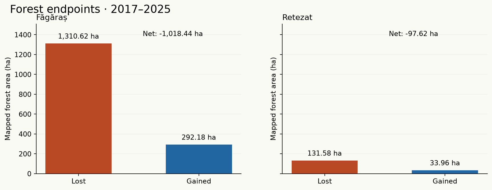
The same annual beta product measures both directions. Endpoint loss and gain compare 2017 with 2025 on one common valid-pixel mask.
| Massif | 2017 forest | 2025 forest | Lost | Gained | Net | Net / baseline |
|---|---|---|---|---|---|---|
| Făgăraș | 116,075.72 | 115,057.28 | 1,310.62 | 292.18 | −1,018.44 | -0.877% |
| Retezat | 31,839.06 | 31,741.44 | 131.58 | 33.96 | −97.62 | -0.307% |
These are changes in modelled forest classes. They are not validated forest-inventory estimates, canopy-density measurements, or proof of permanent deforestation. Tree crops and agroforestry remain outside the forest total.
Nine years.
More than endpoints.
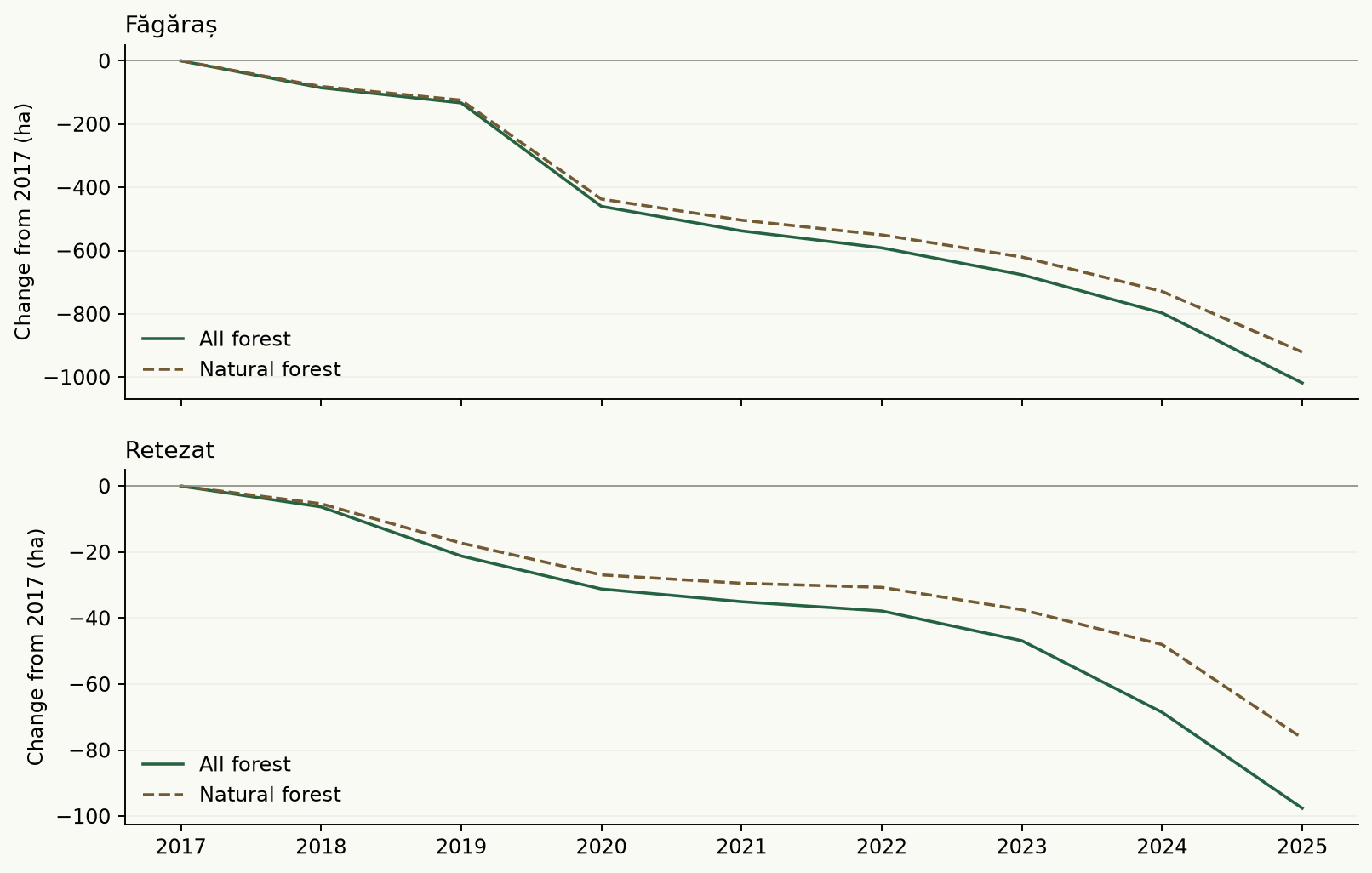
A cell forested in both 2017 and 2025 can lose its forest label and recover between them. Annual history reveals changes that an endpoint balance leaves out.
Făgăraș
View Făgăraș annual measurements
| Year | All forest Δ | Natural Δ | Annual lost | Annual gained |
|---|---|---|---|---|
| 2017 | 0.00 | 0.00 | 0.00 | 0.00 |
| 2018 | −85.29 | −81.22 | 85.74 | 0.45 |
| 2019 | −133.19 | −124.50 | 101.11 | 53.21 |
| 2020 | −460.23 | −437.17 | 421.49 | 94.45 |
| 2021 | −537.74 | −503.82 | 133.66 | 56.15 |
| 2022 | −591.43 | −550.37 | 138.64 | 84.95 |
| 2023 | −676.34 | −620.29 | 161.82 | 76.91 |
| 2024 | −797.15 | −728.97 | 215.15 | 94.34 |
| 2025 | −1,018.44 | −920.71 | 246.31 | 25.02 |
Retezat
View Retezat annual measurements
| Year | All forest Δ | Natural Δ | Annual lost | Annual gained |
|---|---|---|---|---|
| 2017 | 0.00 | 0.00 | 0.00 | 0.00 |
| 2018 | −6.32 | −5.36 | 6.87 | 0.55 |
| 2019 | −21.19 | −17.29 | 20.16 | 5.29 |
| 2020 | −31.19 | −26.92 | 17.46 | 7.46 |
| 2021 | −35.04 | −29.46 | 7.89 | 4.04 |
| 2022 | −37.85 | −30.69 | 9.03 | 6.22 |
| 2023 | −46.86 | −37.47 | 18.29 | 9.28 |
| 2024 | −68.55 | −48.01 | 33.19 | 11.50 |
| 2025 | −97.62 | −76.37 | 31.29 | 2.22 |
| Massif | Natural loss | Natural gain | Natural → planted | Forest recovered by 2025 |
|---|---|---|---|---|
| Făgăraș | 1,196.40 | 275.69 | 0.01 | 185.88 |
| Retezat | 102.20 | 25.83 | 0.00 | 11.25 |
Recovery follows cells forested in 2017 that return to a modelled forest class. It does not establish mature canopy, ecological restoration, or biodiversity recovery. Natural-to-planted conversion counts toward natural-forest loss but not total-forest loss. Later forest gains appear in annual turnover.
The massif
sets the boundary.
These scientific previews use the analytical 10 m rasters, clipped to published Romanian relief polygons. Open a figure at full resolution or download its GeoTIFF to inspect small changes.
Făgăraș
Open full-size map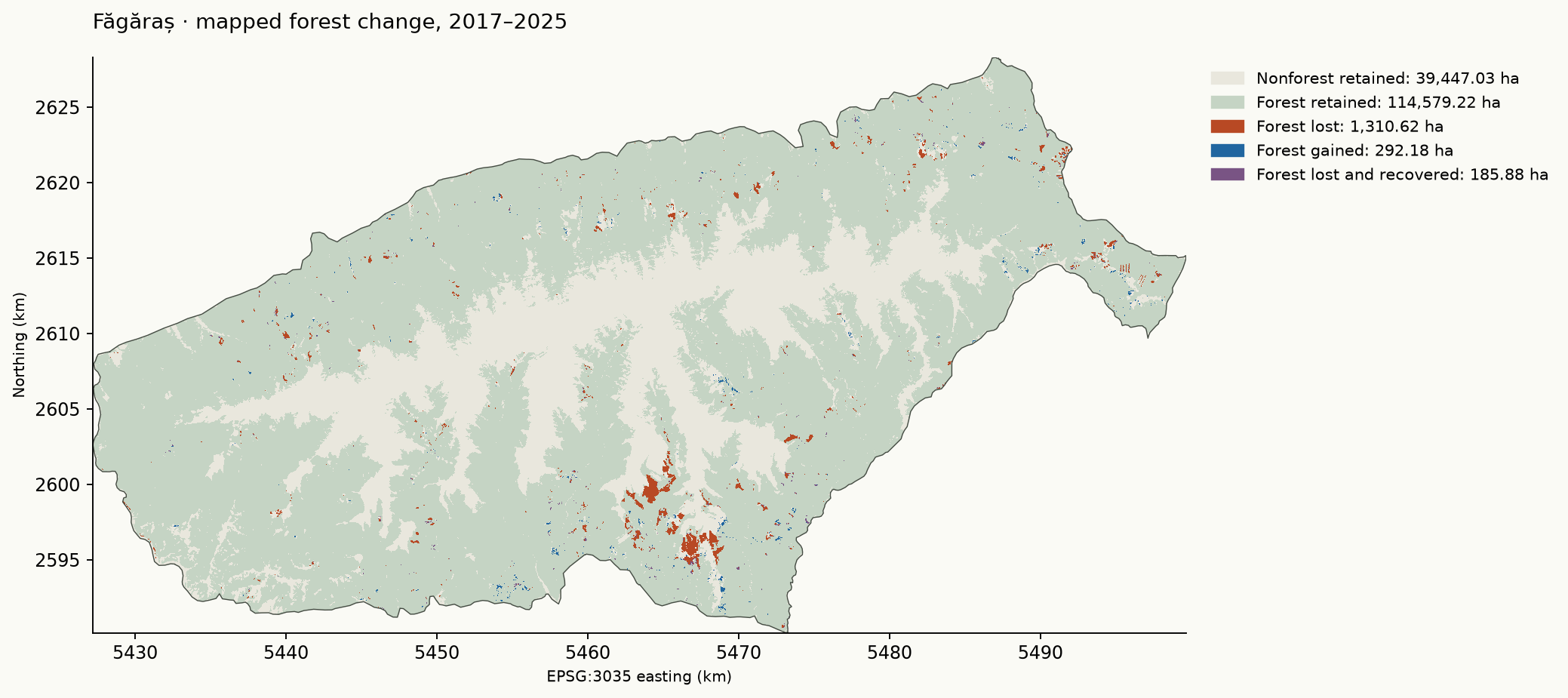
Retezat
Open full-size map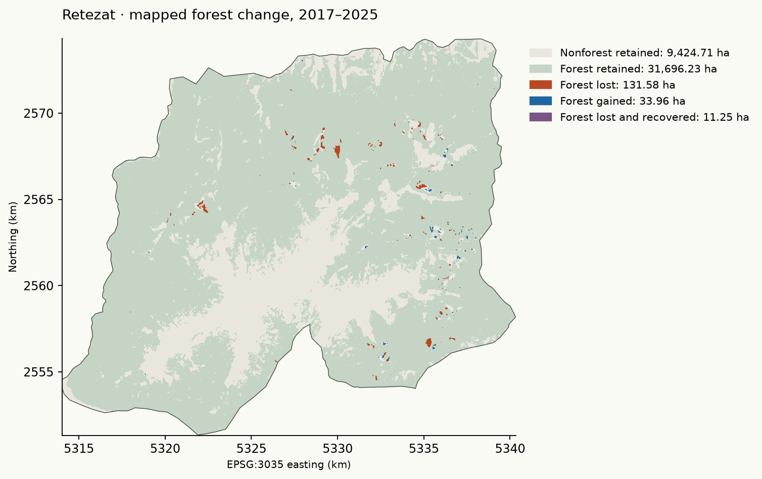
The screening rule
changes the result.
Each rule has its own eligible support. These variations describe methodological sensitivity, rather than statistical confidence intervals or a local accuracy estimate.
Raw endpoints use all common valid cells. Stable endpoints require matching binary forest status in 2017/2018 and 2024/2025. Maximum native-class score filters apply at both endpoints, or all four years for stable endpoints. Excluded cells contribute to neither loss nor gain; scores are uncalibrated model confidence, never canopy percentages.
Făgăraș
| Rule | Score ≥ | Lost | Gained | Net | Excluded |
|---|---|---|---|---|---|
| Raw endpoints | 0.0 | 1,310.62 | 292.18 | −1,018.44 | 0.00 |
| Raw endpoints | 0.5 | 1,275.85 | 286.55 | −989.30 | 854.40 |
| Raw endpoints | 0.7 | 534.08 | 183.16 | −350.92 | 26,226.75 |
| Raw endpoints | 0.9 | No eligible cells | 155,814.93 | ||
| Stable endpoints | 0.0 | 1,023.81 | 288.97 | −734.84 | 356.89 |
| Stable endpoints | 0.5 | 992.07 | 277.76 | −714.31 | 1,239.11 |
| Stable endpoints | 0.7 | 354.77 | 129.50 | −225.27 | 26,567.59 |
| Stable endpoints | 0.9 | No eligible cells | 155,814.93 | ||
Retezat
| Rule | Score ≥ | Lost | Gained | Net | Excluded |
|---|---|---|---|---|---|
| Raw endpoints | 0.0 | 131.58 | 33.96 | −97.62 | 0.00 |
| Raw endpoints | 0.5 | 129.42 | 31.54 | −97.88 | 214.06 |
| Raw endpoints | 0.7 | 69.36 | 14.46 | −54.90 | 7,772.76 |
| Raw endpoints | 0.9 | No eligible cells | 41,297.73 | ||
| Stable endpoints | 0.0 | 96.27 | 32.29 | −63.98 | 40.79 |
| Stable endpoints | 0.5 | 92.53 | 28.84 | −63.69 | 261.86 |
| Stable endpoints | 0.7 | 37.41 | 8.02 | −29.39 | 7,824.73 |
| Stable endpoints | 0.9 | No eligible cells | 41,297.73 | ||
Fixed support.
Traceable evidence.
Every total has a defined measurement, period and geographical support. Input hashes, acquisition records and accounting gates accompany the downloadable results.
| Massif | Polygon | Analytical area (ha) | Common coverage | Missing data (ha) |
|---|---|---|---|---|
| Făgăraș | 552 | 155,814.93 | 100.000% | 0.00 |
| Retezat | 576 | 41,297.73 | 100.000% | 0.00 |
Boundaries & common coverage
The 2008 Romanian relief dataset follows Posea and Badea’s geographical regionalization. Its WGS84 download omits a projection file; the publisher’s GCS_WGS84 designation is used explicitly. These are generalized massif polygons.
All nine years share one valid-pixel mask, with at least 99% coverage required. Each 10 m cell represents 0.01 ha. Pixel centres determine polygon membership, so raster and vector areas differ slightly at the edges.
Classes & comparability
All years use ForTy v2 beta. Forest includes classes 1, 2, 3, 4 and 7; natural forest includes 1, 2 and 7. Tree crops stay separate. The national v1 baseline is never spliced into this series.
Sorted first-valid tile ownership prevents double counting. Model classification changes and temporarily unstocked forest can resemble loss or recovery. No field verification, causal attribution, legal determination or local accuracy estimate is included.
Copernicus coverage & grid details
Official 2018 rasters use an older ETRS89 datum serialization. Exact LAEA/GRS80 projection parameters are verified before normalizing the CRS to EPSG:3035.
| Massif | Product / period | Valid area (ha) | Coverage / excluded |
|---|---|---|---|
| Făgăraș | Density · 2018–2024 | 155,814.93 | 100.000% |
| Făgăraș | Presence · 2018–2021 | 155,816.76 | 0.00 ha excluded |
| Făgăraș | Presence · 2021–2024 | 155,816.76 | 0.00 ha excluded |
| Retezat | Density · 2018–2024 | 41,297.73 | 100.000% |
| Retezat | Presence · 2018–2021 | 41,296.68 | 0.00 ha excluded |
| Retezat | Presence · 2021–2024 | 41,296.68 | 0.00 ha excluded |
Reproduce the research & read the rasters
From the project root: uv run forest-lab balance. With all inputs cached: FOREST_LAB_OFFLINE=1 uv run --offline forest-lab balance. Focused checks: uv run --offline pytest -q tests/test_balance.py.
Change-raster codes: 0 outside or excluded; 1 nonforest retained; 2 forest retained; 3 endpoint loss; 4 endpoint gain; 5 forest lost and recovered by 2025. Annual raster bands preserve native classes 1–7.
Sources & attribution
- Romanian relief boundaries Bogdan Candrea, Petronela Candrea, Mihai Daniel Niță; regionalization after Posea and Badea (1984).
- ForTy release & annual beta series Neumann and colleagues · Google DeepMind, Google Research, WRI and IIASA · 2026.
- Official ForTy beta explorer Native band definitions and experimental annual maps.
- Hansen Global Forest Change 2025 v1.13 University of Maryland, Google, USGS and NASA.
- Copernicus Tree Cover Density European Union · EEA / JRC · 2018 and 2024.
- Copernicus Tree Cover Presence Change 2018–2021 and 2021–2024 · product marked not validated.
- WRI interpretation & comparability limits Read the definitions before comparing products.
Take the evidence
with you.
Original research artifacts, served locally. Tables retain their full numerical precision; GeoTIFFs retain the analytical resolution and coordinate system.
Tables
Geospatial data
- Published massif boundariesGEOJSON · 40 KB
- Făgăraș · annual classesTIF · 1.1 MB
- Făgăraș · forest changeTIF · 323 KB
- Făgăraș · natural-forest changeTIF · 393 KB
- Retezat · annual classesTIF · 338 KB
- Retezat · forest changeTIF · 103 KB
- Retezat · natural-forest changeTIF · 119 KB
- Făgăraș · crown-density changeTIF · 7.1 MB
- Făgăraș · canopy presence 2018–2021TIF · 135 KB
- Făgăraș · canopy presence 2021–2024TIF · 140 KB
- Retezat · crown-density changeTIF · 1.7 MB
- Retezat · canopy presence 2018–2021TIF · 42 KB
- Retezat · canopy presence 2021–2024TIF · 44 KB